Home - Search - Browse - Alphabetic Index: 0- 1- 2- 3- 4- 5- 6- 7- 8- 9
A- B- C- D- E- F- G- H- I- J- K- L- M- N- O- P- Q- R- S- T- U- V- W- X- Y- Z
Venera 4V-2

Venera 15
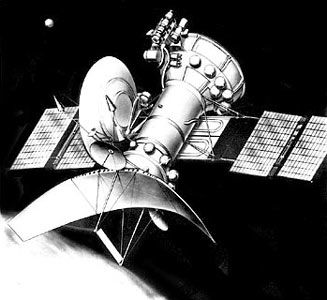
Venera-15 Venus radar lunar surface mapper
Credit: Andy Salmon
AKA: 4V-2. Status: Operational 1983. First Launch: 1983-06-02. Last Launch: 1983-06-07. Number: 2 . Gross mass: 4,000 kg (8,800 lb).
In comparison to the 4V-1 bus flown previously they had extra solar panels and their propellant compartments were lengthened by a little over one meter.
Two spacecraft were inserted into Venus orbit a day apart with their orbital planes shifted by an angle of approximately 4 degrees relative to one another. This made it possible to reimage an area if necessary. Each spacecraft was in a nearly polar orbit with a periapsis at 62 N latitude. Together, the two spacecraft imaged the area from the north pole down to about 30 degrees N latitude over the 8 months of mapping operations. Each spacecraft consisted of a 5 m long cylinder with a 6 m diameter, 1.4 m tall parabolic dish antenna for the synthetic aperture radar (SAR) at one end. A 1 meter diameter parabolic dish antenna for the radio altimeter was also located at this end. The electrical axis of the radio altimeter antenna was lined up with the axis of the cylinder. The electrical axis of the SAR deviated from the spacecraft axis by 10 degrees. During imaging, the radio altimeter would be lined up with the center of the planet (local vertical) and the SAR would be looking off to the side at 10 degrees. A bulge at the opposite end of the cylinder held fuel tanks and propulsion units. Two square solar arrays extended like wings from the sides of the cylinder. A 2.6 m radio dish antenna for communications was also attached to the side of the cylinder.
More at: Venera 4V-2.
Family: Venus. Country: Russia. Engines: KTDU-425A. Launch Vehicles: Proton, Proton-K/D-1. Projects: Venera. Launch Sites: Baikonur, Baikonur LC200/40, Baikonur LC200/39. Agency: MOM, Lavochkin bureau. Bibliography: 2, 274, 296, 428, 6, 67, 7016, 13339.
 | Venera 15 Credit: Manufacturer Image |
1983 June 2 - . 02:38 GMT - . Launch Site: Baikonur. Launch Complex: Baikonur LC200/39. LV Family: Proton. Launch Vehicle: Proton-K/D-1.
- Venera 15 - .
Payload: 4V-2 s/n 860. Mass: 4,000 kg (8,800 lb). Nation: Russia.
Agency: MOM.
Program: Venera.
Class: Venus.
Type: Venus probe. Spacecraft Bus: 4MV.
Spacecraft: Venera 4V-2.
USAF Sat Cat: 14104 . COSPAR: 1983-053A. Apogee: 65,000 km (40,000 mi). Perigee: 1,000 km (600 mi). Inclination: 87.50 deg. Period: 1,440.00 min.
Venera 15 was part of a two spacecraft mission (along with Venera 16) designed to use side-looking radar mappers to study the surface properties of Venus. The two spacecraft were inserted into Venus orbit a day apart with their orbital planes shifted by an angle of approximately 4 degrees relative to one another. This made it possible to reimage an area if necessary. Each spacecraft was in a nearly polar orbit with a periapsis at 62 N latitude. Together, the two spacecraft imaged the area from the north pole down to about 30 degrees N latitude over the 8 months of mapping operations. Data is for Venus orbit.
1983 June 7 - . 02:32 GMT - . Launch Site: Baikonur. Launch Complex: Baikonur LC200/40. LV Family: Proton. Launch Vehicle: Proton-K/D-1.
- Venera 16 - .
Payload: 4V-2 s/n 861. Mass: 4,000 kg (8,800 lb). Nation: Russia.
Agency: MOM.
Program: Venera.
Class: Venus.
Type: Venus probe. Spacecraft Bus: 4MV.
Spacecraft: Venera 4V-2.
USAF Sat Cat: 14107 . COSPAR: 1983-054A.
Venus radar mapper; entered Venus orbit 10/14/83. Venera 16 was part of a two spacecraft mission (along with Venera 15) designed to use side-looking radar mappers to study the surface properties of Venus. The two spacecraft were inserted into Venus orbit a day apart with their orbital planes shifted by an angle of approximately 4 degrees relative to one another. This made it possible to reimage an area if necessary. Each spacecraft was in a nearly polar orbit with a periapsis at 62 N latitude. Together, the two spacecraft imaged the area from the north pole down to about 30 degrees N latitude over the 8 months of mapping operations.
1983 October 10 - .
- Venera 15, Venus Orbit Insertion - . Nation: Russia. Spacecraft Bus: 4MV. Spacecraft: Venera 4V-2.
1983 October 16 - .
- Venera 16, Venus Orbit Insertion - . Nation: Russia. Spacecraft Bus: 4MV. Spacecraft: Venera 4V-2.
Back to top of page
Home - Search - Browse - Alphabetic Index: 0- 1- 2- 3- 4- 5- 6- 7- 8- 9
A- B- C- D- E- F- G- H- I- J- K- L- M- N- O- P- Q- R- S- T- U- V- W- X- Y- Z
© 1997-2019 Mark Wade - Contact
© / Conditions for Use